Assessing the trawling footprint of Australian fisheries
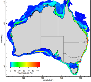
Press release November 19, 2018 Trawling Fishing FootprintThe first national picture of the footprint of bottom trawling on Australia’s seabed habitats has just been released. Overall, less than 3.5% of the Australian seabed was found to be affected by trawling in recent years. Although this figure varies regionally, it is among the lowest footprints recorded worldwide.

The work analysed the most comprehensive data available for seabed biodiversity to map a total of 217 seabed eco-regions (as surrogates for habitats) around Australia and found that most had little or no exposure to trawling.
The report, conducted by the CSIRO in collaboration with all states, and funded by the Fisheries Research and Development Corporation (FRDC), provides a map of which seabed habitats are most exposed to trawling and are the highest priorities for future detailed risk assessment studies.
Some of the areas identified as highest priorities for ecological risk assessment are the Australian east coast from southern Queensland including deep areas of the southern Great Barrier Reef, through shelf areas of NSW, to eastern Victoria/Bass Strait — as well as western Tasmania to SE South Australia near the shelf break, in Shark Bay, and the outer Great Australian Bight.
“Some eco-regions in these areas have high trawl footprints (between 30% and 65% trawled) and typically have low protection (such as in fishery closures and/or marine reserves), and will need to be assessed first”, says CSIRO’s Dr Roland Pitcher who led the research.
“To date, ecological risk assessments for Australian trawl fisheries have largely focussed on evaluating which bycatch species are at high risk. However, research has also shown that fishing gear towed along the bottom of the sea can impact seabed habitats” continues Dr Pitcher “Most fisheries currently lack adequate data for ecological risk assessments of habitats, but in some fisheries, the nature and diversity of some habitats indicate possible risks from different fishing gears and new data needs to be collected”.
The identification of the priority trawl‐exposed eco-regions reflects potential, rather than confirmed risk to habitat. Future assessments need to determine the occurrence and distributions of sensitive habitats within priority eco-regions and assess their level of risk. Should risk management be required, a suite of measures can be evaluated for minimising seabed impacts of trawls, including gear modifications.
“This approach will ultimately lead to outcomes that include reduction of the ecological risks posed by trawling and improved environmental sustainability” says Dr Pitcher.
The mapping of Australian trawl footprints used high-resolution trawl effort data and included all State and Commonwealth trawl and dredge fisheries, and where habitats straddled jurisdictions, researchers considered the cumulative footprints of multiple fisheries.
This Australian study was conducted in parallel with an international collaborative project that also used high-resolution trawl effort data to map trawl footprints in 24 regions worldwide. The results, recently published in the journal PNAS, showed the average trawl footprint was 14% overall of the studied regions. “Trawl footprints in the five Australian regions were among the lowest of the 24 regions included in the study” says Dr Pitcher, “whereas European regions had the highest footprints.”
Full lists of the co-authors of these studies are available in the report and in the paper.
The FRDC through investing in knowledge, innovation, and marketing aims to increase economic, social and environmental benefits for Australian fishing and aquaculture, and the wider community.
The FRDC is a co-funded partnership between its two stakeholders, the Australian Government and the fishing and aquaculture sectors.
---
Image caption: Map of bottom trawling footprint in Australia
Image credit: CSIRO
Contact –Peter Horvat
Manager of Communications, Trade and Marketing
Fisheries Research and Development Corporation
D +61 2 6285 0414
M +61 415 933 557
E[email protected]
Subjects
Trawling Fishing Footprint